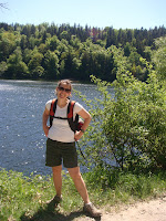
 Yesterday, Kevin and I spent a wonderful day hiking in one of Germany's 14 national parks, Nationalpark Eifel. Located about 85K west of Bonn, the park occupies over 100 square kilometers in the Eifel Mountains. The range was formed by volcanic eruptions and is home to forested rolling hills, valleys, streams, and lakes.
We began our day at Simmerath-Rurberg, one of the three information centers. Though we simply plugged the address into our navi, it would have been easy to find without it. Roads leading from the A1 into the park were well marked with brown signs.

In the information center we were pleased to find a helpful English-speaking attendant and an excellent, very detailed map (for 10 Euros). With tons of trails at varying levels of difficulty, it was easy to find a hike to suit us.
We hiked about 12k, walking along a lake then cutting through the forest before looping back to the water. The paved or gravel trails, which we shared with mountain bikers, were easy to follow with our map. Along the way there were benches and even a picnic area.
Highlights of the day included speaking with a German couple (in German of course) about the Wild boars that recently tore up the picnic area, and sitting in the grass at the end of the hike watching the swimmers and basking in the sun.


No comments:
Post a Comment